|
|
Isabel
Sept 14, 2003 12:41:46 GMT -5
Post by Lyle on Sept 14, 2003 12:41:46 GMT -5
This will be worth keeping an eye on over the next couple of days and taking precautions accordingly. Details here: www.nhc.noaa.gov/ |
|
|
|
Isabel
Sept 14, 2003 14:40:58 GMT -5
Post by A "CJ" on Sept 14, 2003 14:40:58 GMT -5
I for see a massive clean up at the shipyard this week.
tim
|
|
|
|
Isabel
Sept 14, 2003 16:46:50 GMT -5
Post by LILREDCJ6 on Sept 14, 2003 16:46:50 GMT -5
All i got to say is if she hits here she needs to be gone by Fri Morn because that is when the wife surgery is. All i can say is if it could go wrong it will go wrong for us. Hopefully it will be out of our way so she can get this over with.
Tony
|
|
|
|
Isabel
Sept 14, 2003 17:09:42 GMT -5
Post by TheMaddRamm on Sept 14, 2003 17:09:42 GMT -5
Man, I just sold that D60 ad other stuff and I am supposed to deliver it to NC mid next week. Dangit!  |
|
|
|
Isabel
Sept 15, 2003 20:55:38 GMT -5
Post by Lyle on Sept 15, 2003 20:55:38 GMT -5
Current forecast track has moved slightly to the west... not good news.
WTNT43 KNHC 152051
TCDAT3
HURRICANE ISABEL DISCUSSION NUMBER 39
NWS TPC/NATIONAL HURRICANE CENTER MIAMI FL
5 PM EDT MON SEP 15 2003
AIRCRAFT RECONNAISSANCE OBSERVATIONS CONFIRM THAT ISABEL HAS
WEAKENED TO CATEGORY THREE STATUS. PEAK FLIGHT LEVEL WINDS OF 120
KT SUPPORT SURFACE WINDS OF ABOUT 110 KT...WHICH IS THE ADVISORY
INTENSITY...ALTHOUGH DROPSONDES IN THE EYEWALL SUGGEST THE WINDS
MIGHT BE EVEN A LITTLE BIT LESS. THERE IS NOT MUCH EVIDENCE OF
SHEAR AND THE OUTFLOW PATTERN STILL LOOKS STRONG. HOWEVER...THE
EYEWALL CONVECTION REMAINS ASYMMETRIC AND THE WEST SIDE OF THE
CIRCULATION LOOKS A LITTLE DRY. ALTHOUGH ISABEL HAS BEEN
WEAKENING...AND MAY WEAKEN FURTHER...THERE IS SOME MODEL GUIDANCE
THAT SUGGESTS THAT A MORE FAVORABLE UPPER WIND PATTERN...WITH
ENHANCED ANTICYCLONIC OUTFLOW...MAY DEVELOP IN THE LAST 24 HOURS
BEFORE LANDFALL. HOWEVER...DYNAMICAL MODELS HAVE LIMITED SKILL IN
PREDICTING SUCH PATTERNS...IN PARTICULAR THEY OFTEN OVER-DEVELOP
UPPER-LEVEL ANTICYCLONES OVER TROPICAL CYCLONES. THE OFFICIAL
FORECAST SIMPLY CALLS FOR LITTLE CHANGE IN STRENGTH...AND
ANTICIPATES A MAJOR HURRICANE...CATEGORY THREE OR HIGHER...AT
LANDFALL.
|
|
|
|
Isabel
Sept 15, 2003 21:06:18 GMT -5
Post by A "CJ" on Sept 15, 2003 21:06:18 GMT -5
Lyle, thanks for the good news. Working tonight midnight til whenever to get things done at the shipyard. Never a dull moment, at least the pay is good...... ;D
tim
|
|
|
|
Isabel
Sept 15, 2003 21:10:56 GMT -5
Post by Lyle on Sept 15, 2003 21:10:56 GMT -5
Hey Tim!
I wish this thing would turn, but from where it is, the only good way for it to turn would be to turn around. Be careful out there, and don't forget to batten down the hatches at home, too!
Lyle
|
|
|
|
Isabel
Sept 15, 2003 21:50:16 GMT -5
Post by Lyle on Sept 15, 2003 21:50:16 GMT -5
GOES Image:  |
|
|
|
Isabel
Sept 17, 2003 22:06:13 GMT -5
Post by Lyle on Sept 17, 2003 22:06:13 GMT -5
Ships leaving Norfolk Tuesday morning: 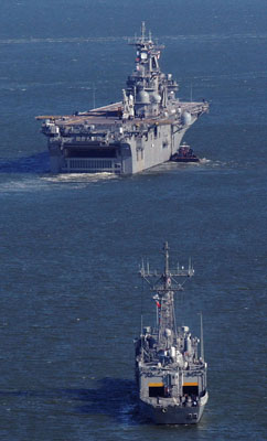 By JACK DORSEY, The Virginian-Pilot © September 17, 2003 | Last updated 10:16 PM Sep. 16 All non-essential Navy personnel are being asked to voluntarily evacuate Hampton Roads beginning Wednesday, and some commands are extending an unusually liberal leave policy, saying they need not return to work until Monday. Rear Adm. Stephen A. Turcotte, commander of the Navy's Mid-Atlantic Region, recommended families look at their specific situations, then decide whether to take advantage of temporary shelters the Navy is making available. ``Essentially each person needs to evaluate with their family their personal safety since everyone lives in different areas,'' Turcotte said. ``We recommend they look at voluntarily -- based on their personal situation -- moving to higher ground.'' Navy families seeking shelter outside Hampton Roads are being told to go to Camp AP Hill, an Army post near Fredericksburg. |
|


